Natural Wonders of Asia is all about the spectacular, the beautiful, the amazing wonders of nature found throughout the continent of Asia. Here to provide you with the information you need to become inspired to go explore and experience these wonders of nature.
Dead Sea


The Dead Sea "Sea of Salt", also called the Salt Sea, is a salt lake bordering Jordan to the east and Israel and the West Bank to the west. Its surface and shores are 423 metres (1,388 ft) below sea level, Earth's lowest elevation on land.The deepest hypersaline lake in the world. With 33.7% salinity, it is also one of the world's saltiest bodies of water, It is 8.6 times saltier than the ocean.The Dead Sea area has become a major center for health research and treatment for several reasons. The mineral content of the water, the very low content of pollens and other allergensin the atmosphere, the reduced ultraviolet component of solar radiation, and the higher atmospheric pressure at this great depth each have specific health effects. For example, persons suffering reduced respiratory function from diseases such as cystic fibrosis seem to benefit from the increased atmospheric pressure.
Although sparsely populated and serenely quiet now, the area has a historical and spiritual legacy of its own. It is believed to be the site of five biblical cities: Sodom, Gomorrah, Admah, Zebouin and Zoar.
Amazing thing about this sea is the density of water there are big questions that no one can answer them why there is no sea shore and waves may be this is the reason people named it Dead

Khewra Salt Mines

Khewra Salt Mines is a salt mine located in Khewra, Jhelumas District, Punjab in Pakistan, about 160 kilometres (99 mi) from Islamabad and 260 kilometres (160 mi) from Lahore. It attracts up to 40,000 visitors per year and is the second largest salt mine in the world. Situated in the foothills of the Salt Range, the Khewra Salt Mines are the oldest in the South Asia.Let us share some interesting facts and a true story about the Khewra Salt Mines. The discovery of the world’s second largest salt mine was a very interesting incident. The Salt Mines very discovered in about 320BC. The discovery of the mine was not made by the Alexander and nor his allies but by the horses of the Alexander’s army. This all took place when Alexander the Great visited the South Asia and there was a battle between Alexander the Great and the army of Raja Porus. The army of Alexander just passed through the Jehlum and Mianwali Dists. and they rested here at the bank of the Jehlum River. The horses started licking the stones when they were grazing. One of the soldiers of Alexander’s army observed this and tasted the stone. He found that the stone is actually salt. This is how the world’s second largest salt mine was discovered.
Pakistan K2 is the World second-highest mountain
K2 is the second-highest mountain on Earth, after Mount Everest. With a peak elevation of 8,611 m (28,251 feet), K2 is part of the Karakoram Range, and is located on the border between Gilgit, in Gilgit-Baltistan of Pakistan and the Taxkorgan Tajik Autonomous County of Xinjiang, China. It is more hazardous to reach K2 from the Chinese side; thus, it is mostly climbed from the Pakistani side.

K2 is known as the Savage Mountain due to the difficulty of ascent and the second-highest fatality rate among the "eight thousanders" for those who climb it. For every four people who have reached the summit, one has died trying. Unlike Annapurna, the mountain with the highest fatality rate, K2 has never been climbed in winter.
The HunzaThe Hunza Valley is a mountainous
 valley in Gilgit in the Gilgit-Baltistan region of the Northern Areas of Pakistan. The Hunza valley is situated to the north of the Hunza River, at an elevation of around 2,500 metres (8,200 ft). The territory of Hunza is about 7,900 square kilometres (3,100 sq mi). Karimabad (formerly called Baltit) is the main town, which is also a very popular tourist destination because of the spectacular scenery of the surrounding mountains like Ultar Sar, Rakaposhi, Bojahagur Duanasir II, Ghenta Peak, Hunza Peak, Diran Peak and Bublimating (Ladyfinger Peak), all 6,000 metres (20,000 ft) or higher.
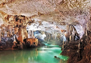
 Puerto Princesa Underground River
The lower portion of the river is subject to tidal influences. The underground river is reputed to be the world's longest. At the mouth of the cave, a clear lagoon is framed by ancient trees growing right to the water's edge. Monkeys, large monitor lizards, and squirrels find their niche on the beach near the cave.A distinguishing feature of the river is that it winds through a cave before flowing directly into the South China Sea. It includes major formations of stalactites and stalagmites, and several large chambers.
Ha Long Bay
 Halong Bay is located in Quáng Ninh province, Vietnam. The bay features thousands of limestone karsts and isles in various sizes and shapes. The bay has a 120 kilometre long coastline and is approximately 1,553 square kilometres in size with 1969 islets. Several of the islands are hollow, with enormous caves, other support floating villages of fishermen, who ply the shallow waters for 200 species of fish and 450 different kinds of mollusks.
Another specific feature of Halong Bay is the abundance of lakes inside the limestone islands, for example, Dau Be island has six enclosed lakes. All these island lakes occupy drowned dolines within fengcong karst.
 The Chocolate Hills is an unusual geological formation in Bohol province, Philippines. There are at least 1,260 hills but there may be as much as 1,776 hills spread over an area of more than 50 square kilometres (20 sq mi).hey are covered in green grass that turns brown during the dry season, hence the name.The Chocolate Hills is a famous tourist attraction of Bohol.The Chocolate Hills form a rolling terrain of haycock hills – mounds of a generally conical and almost symmetrical shape. Estimated to be from 1,268 to about 1,776 individual mounds, these cone-shaped or dome-shaped hills are actually made of grass-coveredlimestone.
 The domes vary in sizes from 30 to 50 metres (98 to 160 ft) high with the largest being 120 metres (390 ft) in height. Bohol's "main attraction", these unique mound-shaped hills are scattered by the hundreds throughout the towns of Carmen,Batuan and Sagbayan in Bohol.
Four legends explain the formation of the Chocolate Hills. The first tells the story of two feuding giants who hurled rocks, boulders, and sand at each other. The fighting lasted for days, and exhausted the two giants. In their exhaustion, they forgot about their feud and became friends, but when they left they forgot to clean up the mess they had made during their battle, hence the Chocolate Hills.
A more romantic legend tells of a giant named Arogo who was extremely powerful and youthful. Arogo fell in love with Aloya, who was a simple mortal. Aloya's death caused Arogo much pain and misery, and in his sorrow he could not stop crying. When his tears dried, the Chocolate Hills were formed..jpg)
 Located in the Kara-Kum desert of Turkmenistan is the village of Darvaza (Derweze) near to where, in 1971, a team of Soviet prospectors allegedly drilled into a large chamber filled with natural gas. The roof of the cavern collapsed leaving a crater-like sinkhole some 25 metres deep with a diameter of approximately 60 – 70 metres. It soon became evident that natural gas was still rising into the crater from even deeper sources and the story goes that the decision was made to ignite the emissions rather than risk either a concentrated build-up of gas or local poisoning.
Chocolate Hills
 The Chocolate Hills is an unusual geological formation in Bohol province, Philippines. There are at least 1,260 hills but there may be as much as 1,776 hills spread over an area of more than 50 square kilometres (20 sq mi).hey are covered in green grass that turns brown during the dry season, hence the name.The Chocolate Hills is a famous tourist attraction of Bohol.The Chocolate Hills form a rolling terrain of haycock hills – mounds of a generally conical and almost symmetrical shape. Estimated to be from 1,268 to about 1,776 individual mounds, these cone-shaped or dome-shaped hills are actually made of grass-coveredlimestone.
 The domes vary in sizes from 30 to 50 metres (98 to 160 ft) high with the largest being 120 metres (390 ft) in height. Bohol's "main attraction", these unique mound-shaped hills are scattered by the hundreds throughout the towns of Carmen,Batuan and Sagbayan in Bohol.
 Four legends explain the formation of the Chocolate Hills. The first tells the story of two feuding giants who hurled rocks, boulders, and sand at each other. The fighting lasted for days, and exhausted the two giants. In their exhaustion, they forgot about their feud and became friends, but when they left they forgot to clean up the mess they had made during their battle, hence the Chocolate Hills.
A more romantic legend tells of a giant named Arogo who was extremely powerful and youthful. Arogo fell in love with Aloya, who was a simple mortal. Aloya's death caused Arogo much pain and misery, and in his sorrow he could not stop crying. When his tears dried, the Chocolate Hills were formed.
.jpg)
The third legend tells of a town being plagued by a giant carabao, who ate all of their crops. Finally having had enough, the townsfolk took all of their spoiled food and placed it in such a way that the carabao would not miss it. Sure enough, the carabao ate it, but his stomach couldn't handle the spoiled food, so he defecated, leaving behind him a mound of feces, until he had emptied his stomach of the food. The feces then dried, forming the Chocolate Hills.
The last legend is about a gluttonous giant named Miguel that eats everything in his path. One day he came to a plain. He saw a beautiful young woman named Adrianna. To win her affection, he needed to lose weight. So he excreted everything he ate. In the end, his fecal matter covered the land and he won Eng's affection.
The last legend is about a gluttonous giant named Miguel that eats everything in his path. One day he came to a plain. He saw a beautiful young woman named Adrianna. To win her affection, he needed to lose weight. So he excreted everything he ate. In the end, his fecal matter covered the land and he won Eng's affection.
Gates to Hell


According to various sources it has burned continuously since then and has apparently been named “The Gate to Hell” by the local people. However, another source that spoke with the guides from the region claims that it is a wholly natural phenomenon.
Nobody knows for sure how much gas has been wasted and for how long it will continue to burn. Doesn’t this story remind you of the Centralia PA mine fire?Sundarbans Forest
 The Sundarbans Forest is the largest collection of tidal halophytic mangroves in the world.
The Sundarbans Forest is home to the Royal Bengal Tiger. The Sundarbans provide a unique ecosystem and series of habitats for a wide variety of wildlife. In addition to the tiger, 42 species of mammals, 35 reptiles and amphibians, 270 species of birds, and over 120 species of fish. Many of these are endangered.
Jeita Grotto is a set of interconnected limestone caves located in Lebanon. A river runs through the two caves referred to as the lower cave and the upper galleries. The Jeita Grotto is the longest cave complex in the Middle East with a height difference of 1,000 feet. The Jeita Grotto sits at 980 feet above sea level. Explorers have made there way 22,700 feet from the front entry way of the lower grotto to the deepest end of the underground river, and about 7,000 feet of the upper galleries. The upper galleries features stalactites, stalagmites, columngs, mushrooms, ponds, curtains and draperies. The effects and views of the cave have been enhanced with a good lighting system. The longest stalactite in the world is found in the White Chamber of the Jeita Grotto.

The Sundarbans Forest is home to the Royal Bengal Tiger. The Sundarbans provide a unique ecosystem and series of habitats for a wide variety of wildlife. In addition to the tiger, 42 species of mammals, 35 reptiles and amphibians, 270 species of birds, and over 120 species of fish. Many of these are endangered.

Jeita Grotto
Guilin Mountains


Mount Damavand

Mount Damavand is a dormant volcano located in Iran. With the summit reaching 18,406 feet (5,610 m), it is the highest peak in Iran and the Middle East and it is the highest volcano in all of Asia.Mount Damavand is part of the Alborz mountain range. it is located near the southern coast of the Caspian Sea As a dormant stratovolcano, Mount Damavand features fumaroles towards the peak which have spewed sulfur as recently as 2007.
Additionally, Mount Damavand features thermal springs. Combined with the fumaroles, the hot springs give evidence that hot magma is still present beneath the volcano.
 Al-Hasa Oasis is the largest natural oasis in Saudi Arabia and all of Asia. The oasis is located just over 40 miles west of the Arabian Gulf. Statistically speaking, the oasis accounts for 30,000 acres. Al-Hasa is one of the largest oasis in the world, and it is the largest in all of Asia. There are over 60 artesian springs that feed the oasis along with a large underground aquifer as well. Collectively, these provide water and irrigation to over 3 million date palms as well as the million residents of the area.
Al-Hasa Oasis


Al-Ahsa has been inhabited since prehistoric times, due to its abundance of water in an otherwise arid region.
Cox’s Bazar Beach

Stone Forests, China

The Naigu Stone Forest and and the Suogeyi Village are protected UNESCO Sites since 2007. According to Unesco.org, the stone forests of Shilin, Yunnan Province “represent one of the world’s most spectacular examples of humid tropical to subtropical karst landscapes. The stone forests of Shilin are considered superlative natural phenomena and a world reference with a wider range of pinnacle shapes than other karst landscapes with pinnacles, and a higher diversity of shapes and changing colors.

Mount Everest


While not posing substantial technical climbing challenges on the standard route, Everest presents dangers such as altitude sickness, weather and wind.
Huanglong Nature Reserve

There are two tails about the origin name of Huanglong (literally “Yellow Dragon”) . First Huanglong is also called “Se’ercuo” in Tibetan Language meaning the golden lake.

Local Tibetans believe the colored ponds of Huanglong and the sacred mountain Xuebaoding are an invisible integrity, the shining colored ponds being tributes to the sacred mountain.
Secondly, Huanglong is called so after all of its fascinating landscapes and sacred temples and monasteries. According to local county annals, it is said that Dayu, a legendary flood control emperor, assembled his people to Maozhou perfacture for water control works. The yellow dragon carried his boat and gave him lots of help. Since then ‘floods seldom haunted the land, and water flew in ts natural course to the Minjiang River. The yellow dragon becomes an immortal in heaven, leaving appealing mountains and colorful waters for the tribute of generation after generation
.jpg) The name for the region in Mongolia is Hongory Els, meaning "Singing Sands." It refers to noise made by sand grains as they pass over each other when wind moves them across the surface of the dunes. Unlike most sand particles, which are coarse and irregular, the particles of the Singing Sands are round and smooth. In dry weather conditions, these particles of sand rub against each other, creating an eerie musical sound. Singing sand, whistling sand or barking sand is sand that produces sounds of either high or low frequency under pressure. The sound emission is usually triggered by wind passing over dunes or by walking on the sand. The sound is generated by shear stress.
The name for the region in Mongolia is Hongory Els, meaning "Singing Sands." It refers to noise made by sand grains as they pass over each other when wind moves them across the surface of the dunes. Unlike most sand particles, which are coarse and irregular, the particles of the Singing Sands are round and smooth. In dry weather conditions, these particles of sand rub against each other, creating an eerie musical sound. Singing sand, whistling sand or barking sand is sand that produces sounds of either high or low frequency under pressure. The sound emission is usually triggered by wind passing over dunes or by walking on the sand. The sound is generated by shear stress.

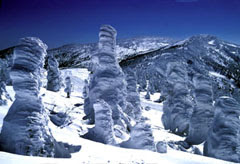 Another natural wonder of Japan that you will certainly find interesting is the trees in Mt. Zao that are covered in snow. The snow that covers the trees makes a shape that are entertaining, resembling humans and animals. This is due to the cold wind that blows down from Siberia during the winter and when the wind passes through Mt. Zao, the moisture will form droplets and becomes supercooled. The trees that live there will be covered with snow and forms those amazing shapes. Tourism has been increasing in this place every year because of the amazing skiing place and the splendor of the snow covered trees it gives.
Singing Sands, Gobi Desert, Mongolia
.jpg)
Mount Fuji
Mount Fuji is the tallest mountain in Japan with the peak reaching an elevation of 12,388 feet. The mountain is located on the west of Tokyo near the boundary of Shizuoka and Yamanashi. Mount Fuji can be seen from Tokyo on clear days. Mount Fuji is most known for the symmetrical cone shape that is often snow covered creating a spectacular scene across Lake Kawaguchi. Mount Fuji is actually surrounded by five lakes that include: Lake Kawaguchi, Lake Yamanaka, Lake Sai, Lake Motosu and Lake Shoji. The mountain is part of the Fuji-Hakone-Izu National Park. 
Lake Mashu Japan

Lake Mashu is a landlocked endorheic crater lake formed in the caldera of a potentially active volcano. It is located in Akan National Park on the island of Hokkaidō, Japan. The lake has been called the clearest lake in the world.The crystal clear water and the mist that surrounds Lake Mashu are one of the features that this place is known for. The visibility of the water of the lake reaches to 137 feet which is a world record. Heavy mist shrouds the lake and this is why Lake Mashu is considered the mysterious lake, which is hidden and out of reach. In the center of this lake is an island that is actually the peak of a lava hill that runs down 230 meters below the surface of the lake. And another mysterious thing about this lake is that it has no rivers flowing in or out, but the water level is still the same throughout the year.
Frost Covered Trees in Mt. Zao

Golden Rock

 Lonar Crater Lake
Columnar Basaltic Lava

When the surface of a lava flow is cooled rapidly, hexagonal patterns (columnar basalt) may form perpendicular to the flow direction. These "organ pipe" basalt columns are adjacent to the sea at the black volcanic sand beach of Reynisfjara, near Vik.
Phi Phi Island
